Showing 53 items matching eucalyptus gum tree
-
 Federation University Historical Collection
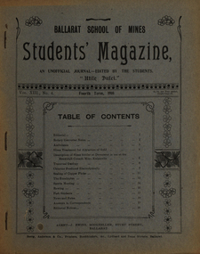
Magazine - Booklet, Ballarat School of Mines, Student Magazine, Fourth Term, 1910
... eucalyptus gum tree... transvaal geology eucalyptus gum tree w.t. lakeland lewis westcottm ...Table of Contents: Editorial, Rotary converter notes, Ambulance, Slime treatment for attraction of gold, Description of slime settler or dewaterer in use at the Brownhill Consols mine Kalgoorlie, Transvaal geology, Chlorine produced electrolytically, Scaling of copper plates, The eucalyptus, Sports meeting, Rowing, Past students, News and notes, Answers to correspondents, Editorial notices. Images.Magazine of 24 pages. Page 17 lists the whereabout of past Ballarat School of MInes students: J.R. Booth, W.t. Lakeland, Lewis Westcottm Leo M. Seward, Reginald Williamson, Stanley White, Clyde Allan, Charles Lamb, W.E. Eyres, Virgil Tucker, H. Hawkesworth, H.J. Saw, Fred G. Brisnden, C. Stevenson, Fred Treloar, J. Peart, E.M. Weston, Dick Galloway, H.B. Bennetts, G.R. Curry, H. Meadows, Eric Bieske, Cliff Garrard, Phil Brown, Lindsay D. Cameron, Phil Brown,, W.P. Avery, J. Foster, J. Bickett, F.H. Inglis, G. Devenport, t. lennon, h. wilkins, g.h. reid, c. hesselman, E. Fraser, Reginald Callister, F. Bicknell, Leslie Blick, W.T. Sayer, W.F. Hall, O.e. Jaeger, W. Gelard, P.C. Downes, G. Sides, F. Bruce, Frank Bruce.rotary converter, ambulance, slime treatment for attraction of gold, slime settler or dewaterer, brownhill consols mine kalgoorlie, transval geology, chlorine produced electrolytically, scaling of copper plates, eucalyptus, alumni, rollo e. huntley, j.r. booth, w. t. lakeland, lewis westcott, leo m. seward, reginald williamson, stanley white, clyde allan, charles laird, w. e. eyers, virgil tucker, h. hawkesworth, h. j. saw, fred g. brinsden, c. stevenson, fred treloar, j. peart, e. m. weston, dick galloway, h. b. bennetts, g. r. curry, h. meadows, will watson, don cameron, eric bieske, cliff garrard, lindsay d. cameron, phil brown, w. p avery, j. foster, james bickett, f. h. inglis, g. davenport, l. c. courbould, t. lennon, h. wilkins, g. h. reid, c. hesselmann, e. fraser, reginald callister, f. bicknell, leslie blick, w. t. sayer, h. f. hall, o. e. jaeger, w. geldard, p. c. downes, g. sides, f. bruce, e. c. hurdsfield, william baragwanath, r. i. moore, j. l. sampson, h. conran, w. gelard, frederick j. martell, h. cornell, g.c. klug, great fingall consolidated ltd, transvaal geology, eucalyptus gum tree, w.t. lakeland, lewis westcottm leo m. seward, charles lamb, w.e. eyres, h.j. saw, fred g. brisnden, e.m. weston, h.b. bennetts, g.r. curry, w.p. avery, j. bickett, f.h. inglis, g. devenport, g.h. reid, c. hesselman, w.t. sayer, w.f. hall, o.e. jaeger, p.c. downes, frank bruce., mt morgan, kalgoorlie, mt elliott copper mine, ballarat city baths, r.b. young -
 Kiewa Valley Historical Society
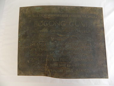
Plaque - Eucalypt Chapmanania, 1947
... ; W.D.Chapman; Eucalyptus; Bogong Gum Tree; Falls Creek road...; Eucalyptus; Bogong Gum Tree; Falls Creek road ...W.D.Chapman had a keen interest in botany and was particularly interested in Eucalyptus species. He was first to discover the tree which now bears his name on his numerous visits to the Kiewa power station which is situated near the Bogong High Plains. He was a Commissioner and later the Chairman of the State Electricity Commission of Victoria, the organisation in charge of building the Kiewa Hydro Scheme. The tree is a cross between two eucalypts. The trees are unique as they cannot procreate. There were two 'Bogong Gum' trees. One at Cranky Charlies and one on the way up to the High Plains passed by the Ryder family on their way up.This plaque was beside the Falls Creek Road and indicated the location of the 'Bogong Gum' tree. The tree was burnt in the 2003 bush fires but survived only to be killed in the 2006 bush fires. There were two 'Bogong Gum' trees. One at Cranky Charlies and one on the way up to the High Plains passed by the Ryder family on their way up. Heavy bronze plaque embossed with inscription. On the back is a large rectangular steel piece bent at the bottom to form a 'U' shape. One end of the 'u' is attached to the plaque and the other end has two holes for bolts enabling the plaque to be attached near the tree. One bolt is in a hole."Type tree from which was first described the species / Bogong Gum / (Eucalyptus Chapmaniana, Cameron) / The species was identified by the / late Brigadier W. D. Chapman M.C.E., / D. Eng., M.I.E. Aust., M.I.C.E. Lond. Commissioner / of the State Electricity Commission / of Victoria from May 1944 to May 1955, / in his honour it was named."plaque; state electricity commission of victoria; w.d.chapman; eucalyptus; bogong gum tree; falls creek road -
 University of Melbourne, Burnley Campus Archives
Slide - Glass slide, 1891-1905
... 'The Giant Gum-Tree (Eucalyptus regnans' F v M... Boulevard Richmond melbourne Glass slide Slide 'The Giant Gum-Tree ...'The Giant Gum-Tree (Eucalyptus regnans' F v M.)' Photograph of pages from books. Line drawings of parts of the plant. australian native plants, eucalyptus, ferdinand von mueller -
 Federation University Historical Collection
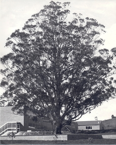
Photograph - Photograph - Black and White, The Tree of Knowledge, c1979
The 'Tree of Knowledge' was planted on Arbor Day 1896 by Mrs Elizabeth Downing who lived on the farm that was originally the Mount Helen Site. When the site was purchased in 1966 the architects and planners inspected the site and decided 'The Big Tree' must remain as a central landmark in preparing the layout of the campus.Photograph of the 'Tree of Knowledge', a Tasmanian Blue Gum (Eucalyptus glubulus labillo), located at the Mount Helen Campus of Federation University. The tree is registered by the National Trust,federation university, federation university australia, feduni, university of ballarat, mount helen, tree of knowledge, big tree, blue gum, mount helen campus -
 Federation University Historical Collection
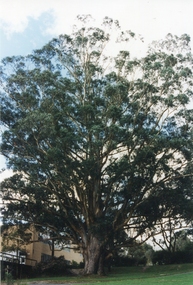
Photograph - Newsprint, The Tree of Knowledge, c2000
The 'Tree of Knowledge' was planted on Arbor Day 1896 by Mrs Elizabeth Downing who lived on the farm that was originally the Mount Helen Site. When the site was purchased in 1966 the architects and planners inspected the site and decided 'The Big Tree' must remain as a central landmark in preparing the layout of the campus.Photograph of the 'Tree of Knowledge', a Tasmanian Blue Gum (Eucalyptus glubulus labillo), located at the Mount Helen Campus of Federation University. The tree is registered by the National Trust,federation university, feduni, university of ballarat, mount helen, tree of knowledge, big tree, blue gum -
University of Melbourne, Burnley Campus Archives
Document, The Sugar Gum Eucalyptus cladocalyx, 2013
... gum eucalyptus trees ...Notes on Sugar Gum and table made from its timbersugar gum, eucalyptus, trees -
 University of Melbourne, Burnley Campus Archives
Album - Digitised, Joanne Morris, Visit to Burnley April 2014, 2014
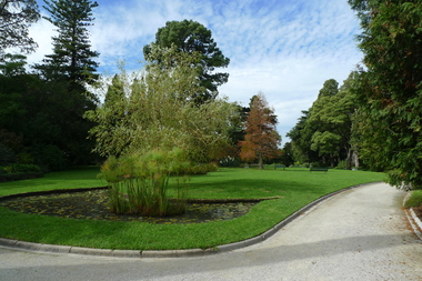
Collection of digitised photographs taken in preparation for the Class of 1973 Reunion in 2014. Garden views and buildings. Donated by Joanne Morris, former student, in June 2014. See Digitised photos- Garden Views folder- Visit to Burnley April 2014. (1) Luffmann Ponds. (2) Administration Building. (3) Emily Gibson Beds and Ginkgo biloba. (4) Looking towards Native Garden. (5) Oak tree. (6) Looking towards Rose Garden. (7) Looking towards Stream Garden and Fern Garden. (8) Looking towards Rose Garden. (9) Plaque at entrance to Field Station. (10) New gates at entrance to Field Station donated by the Friends of Burnley Gardens. (11, 12) Field Station. (13) Plaque in Herb Garden commemorating Enid Carberry. (14) Fountain in Herb Garden commemorating Enid Carberry. (15) Forestry Building. (16-18) Inside Forestry Building. (19) Sugar Gum Table Setting donated by the Friends of Burnley Gardens. (20) Plaque on Sugar Gum Table commemorating Geoff Olive. (21, 22) View of Luffmann Ponds and Summer House. (23) Plaque at Luffmann Ponds. (24) Luffmann Ponds. (25) View of former Egg-Curator's Residence from Nursery. (26) Back of Nursery. (27,28) The Burnley entry for the Melbourne International Flower and Garden Show 2014. (29) Back of Administration Building. (30) Plant Science Laboratories. (31) Student Amenities Building. (32-34) Plant Science Laboratories. (35) Citriodora Court. (36) Eucalyptus maculata at entrance to Native Garden. (37) Native Garden, James Hitchmough Grasslands. (38) Garden view. (39) Inside the Hall. (40,41) Roof Garden. (42,43) Library. (44-50) Views of the Quad and classrooms. (51) Dairy. (52) Building 904,(Centre for Urban Horticulture) now Waterway Ecosystem Research Group. (53) Yarra Boulevard entrance.class 1973, class reunion, garden views, buildings, joanne morris, students, luffmann ponds, administration building, emily gibson beds, ginkgo biloba, native garden, oak tree, rose garden, stream garden, fern garden, field station, friends of burnley gardens, plaques, herb garden, enid carberry, fountain, forestry building, sugar gum table, geoff olive, summer house, egg-curator, residence, nursery, melbourne international flower and garden show, 2014, plant science laboratories, student amenities building, citriodora court, eucalyptus, james hitchmough grasslands, roof garden, library, quad, classrooms, dairy, centre for urban horticulture, waterway ecosystem research group, yarra boulevard entrance -
 University of Melbourne, Burnley Campus Archives
Photograph - Black and white print, Plant Research Institute, 1932
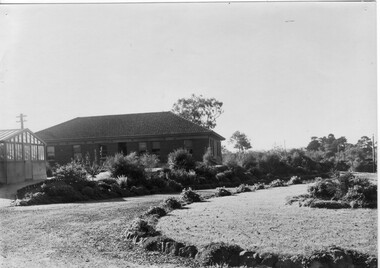
Note by T.H. Kneen 19 November 1991, "The two trees beyond the P.R.L. Are Eucalyptus camaldulensis(Red Gum) and the nearer and taller of the two was severely damaged by a storm (mid fifties). The other tree has survived and is a very good specimen."View of rear of Plant Research Institute/Laboratory (PRI), glasshouse and circular bed.On reverse, "Plant Research Laboratory, Glasshouse & Back Entrance to P.R.L. Dec 1932," signed by A.W. Jessep.plant research laboratory, prl, glasshouse, a.w. jessep, plant research institute, pri, trees -
 University of Melbourne, Burnley Campus Archives
Photograph - Colour prints, John Rayner, Trees, 1978
... ) Eucalyptus cladocalyx, Sugar Gum (2) Cedrus deodara, Himalayan Cedar ...(1) Eucalyptus cladocalyx, Sugar Gum (2) Cedrus deodara, Himalayan Cedareucalyptus, cedars, trees -
 Eltham District Historical Society Inc
Register, Register of Significant Trees, Shire of Eltham, 1993, 1993c
In 1983, the National Trust advised the Shire of Eltham that it was investigating a number of trees within the shire which had been nominated for recording the Register of Significant Trees of Victoria. The trees involved were described in the Shire of Eltham Historical Society Newsletter No. 29, March 1983 as follows:- 1. Eucalyptus melliadora (Yellow box) . a) An outstanding mature specimen 42 metres high in Laughing Waters Road, Eltham. b) Another mature specimen in Arthurs Creek road, Hurstbridge is reported to be the tree under which the bushranger Robert Bourke was tied after he shot and killed Henry Hurst in 1866 . 2. Quercus robur (English Oak). a) "Donaldson's Oak", Donaldsons Road, Kangaroo Ground was planted by John Donaldson from seed collected from Windsor Great Park in 1878. b) "Wippells Oak". This now misshapen tree is located on the St. Andrews Road near the Kangaroo Ground Fire Station. Its origins may have been similar to Donaldson's Oak, and as a young tree it apparently slipped from higher up the hill during wet weather. Both oaks are of local historical importance. 3. Eucalyptus globulus (Blue Gum). A large mature specimen at the corner of the Kangaroo Ground-St. Andrews Road and Bakehouse Road, Panton Hill. 4. Plantanas acerifolia (Plane tree) A number of trees forming the Avenue of Honour to Eltham's First World War soldiers along Main Road between Dalton and Pitt Streets, Eltham. 5. Pinus canariensis (Canary Island Pine), Pinus pinea, (Stone pine) and Cedras altlantica, (Cedar) These trees are located at the Hurst family graves in the grounds of the Hurstbridge Pre-school Centre. In 1991 the Shire of Eltham introduced controls into its planning scheme to protect sites of architectural, historic or conservation interest and significant trees. The controls were approved by the Minister for Planning and Housing. As advised in the Shire of Eltham Historical Society Newsletter No. 78, May 1991, a planning permit is required to demolish or alter any listed building or to destroy, lop or remove any listed tree. Provision is made for comments to be obtained from the National Trust or Historic Buildings Council in considering any applications. The buildings and trees listed were: Buildings: 250 Bolton Street Eltham (former Walter Withers home) "Rosehill" - Bonds Road Lower Plenty St Andrews Church of England - St Andrews "Montsalvat" - Hillcrest Avenue Eltham St Margarets Church and former vicarage - Pitt Street Eltham Presbyterian Church - Kangaroo Ground Parks and Environment Office (former police quarters) Main Road Eltham Former Court House - Main Road Eltham "Shillinglaw Cottage" - Main Road Eltham "The Robins" - Kangaroo Ground Road Warrandyte Trees: "Donaldsons Oak" - Donaldsons Road Kangaroo Ground Yellow Box - Laughing Waters Road Eltham Yellow Box - Arthurs Creek Road Hurstbridge Wippells Oak - St Andrews Road Kanqaroo Road Pines and Cedar - Hurst family cemetery Greysharps Road Hurstbridge Yellow Box - Parsons Road Eltham A large Blue Gum at Panton Hill has been listed but has recently died (1991). In 1993 work by Council Parks and Environment staff and volunteers resulted in the preparation of a Significant Tree Register listing forty-one trees or groups of trees. According to Shire of Eltham Historical Society Newsletter No. 91, March 1993, a similar number remained to be assessed for inclusion in the register. There is a wide range of indigenous and planted trees on private and public land and extending through the Shire of Eltham from Lower Plenty to Kinglake. Most can be viewed from publicly accessible locations. The Significant Tree Register lists 41 trees or groups of trees throughout the Shire. It contains a wide range of naturally occurring and planted trees. They have been assessed according to eleven criteria including size, age, rarity, historical value and the like. The list includes large old Red Gums at Lower Plenty, historic Oaks at Kangaroo Ground and Mountain Ash at Kinglake. The register includes a set of slides showing each tree. Garry Bartlett of the Council's Parks and Environment Section and Faye Shepherd were extensively involved in establishment of the register (Newsletter No. 93, November 1993). In 1999 Niliumbik planners prepared an amendment to the Planning Scheme to provide protection for approximately 200 of the places listed in the heritage studies and also in the Significant Tree Register commenced by the Eltham Council (Eltham District Historical Society Newsletter No. 127, July 1999. In 2004, The Register of Significant Trees was presented to the Eltham District Historical Society by Nillumbik Shire Council as part of a wider collection of of its memorabilia of the former Eltham Shire Council (EDHS Newsletter No. 159, July 2004. Album of loose handmade paper sheets contained within a handmade slip cover constructed of handcrafted card with encapsulated flora material (flowers, vines, ferns) and tinted. Each page also contains an embedded/adhered fern leaf also tinted with lacqueur or similar, text as appropriate in ink by hand calligraphy. Each page also has a white protective sheet cut to size and adhered to back surface with sticky tape and folded over face of page. Pages variously have photographs and coloured masks adhered with a gum resin. Over time much of this resin has let go and photos/masks have been reattached using acid free archival safe adhesive. 15 pages 41 x 29 cm inclusive of 3 blank pages. Slip case 42 x 30 x 1 cm; face cover of slip case has broken off at left hand margin as insufficient depth/flexibility for contents.arthurs creek road, blue gum (eucalyptus globulus), canary island pine (pinus canariensis), couties road, donaldsons oak, donaldsons road, eltham, english oak (quercus robur), eucalyptus melliodora, graysharps road, hurst tree, hurstbridge, ironbark (eucalyptus tricarpa), ironbark hill, kangaroo ground, kangaroo ground-kinglake road, laughing waters road, panton hill hotel, panton hill, parsons road, significant trees register, sonia van bodegraven, sonjart, stone pine (pinus pinea). atlantic cedar (cedrus atlantica), wippells oak, yellow box gum (eucalyptus melliodora), yellow box gum -
 Eltham District Historical Society Inc
Photograph, Liz Pidgeon, Heritage Excursion; East of Eltham, 6 Sep 2014, 20 May 2017
Newsletter No. 218, September 2014 September Excursion - East of Eltham Walk In Newsletter No. 197, March 2011, there was a brief history of Crown Allotment 15 Section 5 Parish of Nillumbik (CA 15) a parcel of land of a quarter of a square mile extending from Eucalyptus Road to Reynolds Road at the eastern extremity of Eltham. From the 1940s it was known as Stokes orchard. In later years it has been subdivided for residential purposes but leaving significant areas as power line and water supply reserves and bushland reserves that are habitat for the threatened For our excursion on 6th September we intend to walk through CA 15 to a bushland reserve east of Reynolds Road. The walk will traverse the boundary between suburban Eltham and the non-urban areas to the south and east. This is a pleasant walk through residential areas and bushland. Along the way we will discuss the early and more recent history of CA 15 as well as local natural history and geology. This walk is about 3.5 km in length and will take 2 to 2.5 hours. It will start at 2pm at the corner of Eucalyptus Road, Pitt Street and Nyora Road.Born Digitaleltham east, eltham district historical society, heritage excursion, activities, nyora road, reynolds road, gum tree road reserve, diosma road, stokes orchard, eucalyptus road -
 Eltham District Historical Society Inc
Photograph, Liz Pidgeon, Heritage Excursion; East of Eltham, 6 Sep 2014, 20 May 2017
Newsletter No. 218, September 2014 September Excursion - East of Eltham Walk In Newsletter No. 197, March 2011, there was a brief history of Crown Allotment 15 Section 5 Parish of Nillumbik (CA 15) a parcel of land of a quarter of a square mile extending from Eucalyptus Road to Reynolds Road at the eastern extremity of Eltham. From the 1940s it was known as Stokes orchard. In later years it has been subdivided for residential purposes but leaving significant areas as power line and water supply reserves and bushland reserves that are habitat for the threatened For our excursion on 6th September we intend to walk through CA 15 to a bushland reserve east of Reynolds Road. The walk will traverse the boundary between suburban Eltham and the non-urban areas to the south and east. This is a pleasant walk through residential areas and bushland. Along the way we will discuss the early and more recent history of CA 15 as well as local natural history and geology. This walk is about 3.5 km in length and will take 2 to 2.5 hours. It will start at 2pm at the corner of Eucalyptus Road, Pitt Street and Nyora Road.Born Digitaleltham east, eltham district historical society, heritage excursion, activities, nyora road, reynolds road, gum tree road reserve, diosma road, stokes orchard, eucalyptus road